Lysterfield Park
- Distance: 4.2 mi
- Elevation gain: 209 m
- Maximum elevation: 201 m
- Elevation loss: 111 m
- Minimum elevation: 69 m
- Moving time: 50 m 5 s
- Moving speed: 5.0 mph
- Maximum speed: 10.2 mph
- Total time: 51 m 13 s
- Global speed: 4.9 mph
Interactive trail map
Trail profile
- Distance: 4.2 mi
- Elevation gain: 209 m
- Maximum elevation: 201 m
- Elevation loss: 111 m
- Minimum elevation: 69 m
- Moving time: 50 m 5 s
- Moving speed: 5.0 mph
- Maximum speed: 10.2 mph
- Total time: 51 m 13 s
- Global speed: 4.9 mph
About this trail
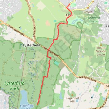
Name: Lysterfield Park trail, distance, elevation, map, profile, GPS track
Coordinates: -37.96222 145.30505 -37.91615 145.32526
Other hiking, mountain biking, running and outdoor activity trails
Click on a trail to view its statistics, map and profile.
Lysterfield Park MTB Loop
Australia > Victoria > Melbourne
#MTB #Loop #Lysterfield
Distance: 10.3 mi • Elevation gain: 380 m • Maximum elevation: 208 m
Lysterfield Lake Loop
Australia > Victoria > Melbourne
Lysterfield Park. #Hiking #Loop #Lysterfield
Distance: 3.6 mi • Elevation gain: 83 m • Maximum elevation: 101 m
Lysterfield Lake Loop
Australia > Victoria > Melbourne
Lysterfield Park. #Hiking #Loop #Lysterfield
Distance: 3.8 mi • Elevation gain: 92 m • Maximum elevation: 105 m
Lysterfield, Baluk William, Mount Morton, Birdsland
Australia > Victoria > Melbourne
Distance: 8.0 mi • Elevation gain: 365 m • Maximum elevation: 267 m
Churchill National Park, Lysterfield Park
Australia > Victoria > Melbourne
Distance: 6.9 mi • Elevation gain: 387 m • Maximum elevation: 224 m
Upwey - Lysterfield Lake
Australia > Victoria > Melbourne
Distance: 15.2 mi • Elevation gain: 735 m • Maximum elevation: 211 m