Seven Bridges Trail
From the upper North Cheyenne Cañon access area, the route first follows Gold Camp Road through a wooded canyon setting before joining Seven Bridges Trail, a popular path known for tracing North Cheyenne Creek.
The itinerary then moves upstream beside the creek, entering denser forest and passing its signature sequence of rustic wooden crossings, with the sound of water, shaded slopes, and narrow canyon scenery shaping the walk.
Beyond the last creek crossings, the trail continues toward the wilder upper drainage and the broader Pike National Forest trail network, giving this short out-and-back route the feel of a gradual transition from park-edge access to mountain-canyon backcountry.
#Hiking #Canyon #River #Forest #Mountain #Nature #Creek #Bridges
- Distance: 3.5 mi
- Elevation gain: 287 m
- Maximum elevation: 2,575 m
- Elevation loss: 287 m
- Minimum elevation: 2,292 m
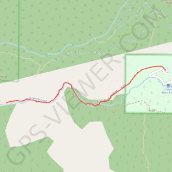
Interactive trail map
Trail profile
- Distance: 3.5 mi
- Elevation gain: 287 m
- Maximum elevation: 2,575 m
- Elevation loss: 287 m
- Minimum elevation: 2,292 m
About this trail
Name: Seven Bridges Trail trail, distance, elevation, map, profile, GPS track
Start: North Cheyenne Canyon Road, El Paso County, Colorado, United States (38.79068 -104.90399)
End: North Cheyenne Canyon Road, El Paso County, Colorado, United States (38.79068 -104.90399)
Coordinates: 38.78623 -104.92954 38.79121 -104.90399
Other hiking, mountain biking, running and outdoor activity trails
Click on a trail to view its statistics, map and profile.
St. Mary's Falls Trail in Pike National Forest
United States > Colorado > El Paso County
The St. Mary’s Falls Trail in Pike National Forest offers a rewarding hike through North Cheyenne Canyon. Beginning on a closed section of Gold Camp Road, the route passes through a mix of aspen and pine forests, offering views of small waterfalls and a flowing creek along the way. The final stretch involves…
Distance: 6.5 mi • Elevation gain: 461 m • Maximum elevation: 2,720 m
Kineo Mountain Trail, Upper Bear Creek and Seven Bridges loop hike
United States > Colorado > El Paso County
Distance: 7.2 mi • Elevation gain: 569 m • Maximum elevation: 2,769 m