
St. Mary's Falls Trail in Pike National Forest
The St. Mary’s Falls Trail in Pike National Forest offers a rewarding hike through North Cheyenne Canyon. Beginning on a closed section of Gold Camp Road, the route passes through a mix of aspen and pine forests, offering views of small waterfalls and a flowing creek along the way. The final stretch involves steeper switchbacks, culminating in a serene setting at St. Mary’s Falls, where the cascading water over granite cliffs provides a refreshing and scenic endpoint. #Hiking #Mountain #Forest #Nature #Waterfall
- Distance: 6.5 mi
- Elevation gain: 461 m
- Maximum elevation: 2,720 m
- Elevation loss: 462 m
- Minimum elevation: 2,292 m
- Moving time: 3 h 21 m
- Moving speed: 1.9 mph
- Maximum speed: 7.7 mph
- Total time: 5 h 3 m
- Global speed: 1.3 mph
Interactive trail map
Trail profile
- Distance: 6.5 mi
- Elevation gain: 461 m
- Maximum elevation: 2,720 m
- Elevation loss: 462 m
- Minimum elevation: 2,292 m
- Moving time: 3 h 21 m
- Moving speed: 1.9 mph
- Maximum speed: 7.7 mph
- Total time: 5 h 3 m
- Global speed: 1.3 mph
About this trail
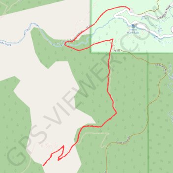
Name: St. Mary's Falls Trail in Pike National Forest trail, distance, elevation, map, profile, GPS track
Start: North Cheyenne Canyon Road, El Paso County, Colorado, United States (38.79091 -104.90417)
End: North Cheyenne Canyon Road, El Paso County, Colorado, United States (38.79079 -104.90413)
Coordinates: 38.77094 -104.91827 38.79123 -104.90408
Other hiking, mountain biking, running and outdoor activity trails
Click on a trail to view its statistics, map and profile.
Seven Bridges Trail
United States > Colorado > El Paso County
From the upper North Cheyenne Cañon access area, the route first follows Gold Camp Road through a wooded canyon setting before joining Seven Bridges Trail, a popular path known for tracing North Cheyenne Creek. The itinerary then moves upstream beside the creek, entering denser forest and passing its…
Distance: 3.5 mi • Elevation gain: 287 m • Maximum elevation: 2,575 m
Kineo Mountain Trail, Upper Bear Creek and Seven Bridges loop hike
United States > Colorado > El Paso County
Distance: 7.2 mi • Elevation gain: 569 m • Maximum elevation: 2,769 m