
Hobsons Lake and Ash Lake Loop in Blue Mountain - Birch Cove Lakes Wilderness Area
- Distance: 4.6 mi
- Elevation gain: 102 m
- Maximum elevation: 108 m
- Elevation loss: 101 m
- Minimum elevation: 61 m
- Moving time: 2 h 10 m
- Moving speed: 2.1 mph
- Maximum speed: 4.2 mph
- Total time: 2 h 32 m
- Global speed: 1.8 mph
Interactive trail map
Trail profile
- Distance: 4.6 mi
- Elevation gain: 102 m
- Maximum elevation: 108 m
- Elevation loss: 101 m
- Minimum elevation: 61 m
- Moving time: 2 h 10 m
- Moving speed: 2.1 mph
- Maximum speed: 4.2 mph
- Total time: 2 h 32 m
- Global speed: 1.8 mph
About this trail
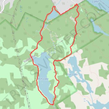
Name: Hobsons Lake and Ash Lake Loop in Blue Mountain - Birch Cove Lakes Wilderness Area trail, distance, elevation, map, profile, GPS track
Coordinates: 44.67282 -63.71935 44.69513 -63.70414
Other hiking, mountain biking, running and outdoor activity trails
Click on a trail to view its statistics, map and profile.

Charlies Lake
Canada > Nova Scotia > Halifax County > Timberlea
Distance: 2.3 mi • Elevation gain: 78 m • Maximum elevation: 107 m
Halifax - Upper Sackville
Canada > Nova Scotia > Halifax County > Halifax
#Bike #Halifax #UpperSackville
Distance: 21.9 mi • Elevation gain: 396 m • Maximum elevation: 138 m