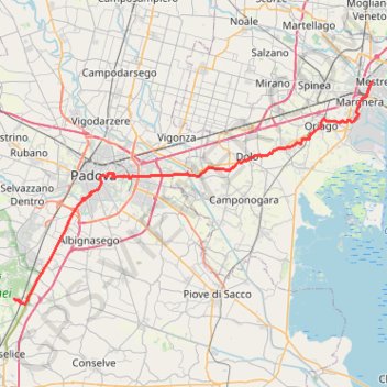
2022_DE_Thermengebiet-Padua-Mestre
- Distance: 34.6 mi
- Elevation gain: 89 m
- Maximum elevation: 21 m
- Elevation loss: 92 m
- Minimum elevation: 1 m
Interactive trail map
Trail profile
- Distance: 34.6 mi
- Elevation gain: 89 m
- Maximum elevation: 21 m
- Elevation loss: 92 m
- Minimum elevation: 1 m
About this trail
Name: 2022_DE_Thermengebiet-Padua-Mestre trail, distance, elevation, map, profile, GPS track
Start: Via Galzignana, Galzignano Terme, Province of Padua, Veneto, 35041, Italy (45.29286 11.76907)
End: Carpenedo, Mestre-Carpenedo, Mestre, Venice, Venezia, Veneto, 30170, Italy (45.49406 12.24161)
Coordinates: 45.28757 11.76907 45.49406 12.24161
Other hiking, mountain biking, running and outdoor activity trails
Click on a trail to view its statistics, map and profile.
Day 23-NOV-22 19:12:44
Italy > Veneto > Province of Padua > Legnaro
Distance: 18.7 mi • Elevation gain: 45 m • Maximum elevation: 13 m
2022_DE_Vicenza-Thermengebiet
Italy > Veneto > Vicenza > Vicenza
Distance: 31.3 mi • Elevation gain: 193 m • Maximum elevation: 53 m