Day 23-NOV-22 19:12:44
- Distance: 18.7 mi
- Elevation gain: 45 m
- Maximum elevation: 13 m
- Elevation loss: 45 m
- Minimum elevation: 7 m
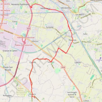
Interactive trail map
Trail profile
- Distance: 18.7 mi
- Elevation gain: 45 m
- Maximum elevation: 13 m
- Elevation loss: 45 m
- Minimum elevation: 7 m
About this trail
Name: Day 23-NOV-22 19:12:44 trail, distance, elevation, map, profile, GPS track
Start: Via Ragazzi del '99, Legnaro, Province of Padua, Veneto, 35020, Italy (45.34245 11.96676)
End: Via Ragazzi del '99, Legnaro, Province of Padua, Veneto, 35020, Italy (45.34253 11.96672)
Coordinates: 45.34245 11.96061 45.41456 12.00795
Other hiking, mountain biking, running and outdoor activity trails
Click on a trail to view its statistics, map and profile.
2022_DE_Thermengebiet-Padua-Mestre
Italy > Veneto > Province of Padua > Galzignano Terme
Distance: 34.6 mi • Elevation gain: 89 m • Maximum elevation: 21 m