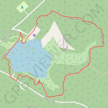
Shaggers Loop
Loop hike from Shaggers Inn Pond via Shaggers Loop and Shaggers Inn Waterfowl Dam in the Moshannon State Forest. #Hiking #Loop #Nature #Forest #Lake
- Distance: 2.2 mi
- Elevation gain: 33 m
- Maximum elevation: 618 m
- Elevation loss: 33 m
- Minimum elevation: 594 m
- Moving time: 50 m 32 s
- Moving speed: 2.6 mph
- Maximum speed: 5.7 mph
- Total time: 1 h 12 m
- Global speed: 1.8 mph
Interactive trail map
Trail profile
- Distance: 2.2 mi
- Elevation gain: 33 m
- Maximum elevation: 618 m
- Elevation loss: 33 m
- Minimum elevation: 594 m
- Moving time: 50 m 32 s
- Moving speed: 2.6 mph
- Maximum speed: 5.7 mph
- Total time: 1 h 12 m
- Global speed: 1.8 mph
About this trail
Name: Shaggers Loop trail, distance, elevation, map, profile, GPS track
Coordinates: 41.19884 -78.42212 41.20628 -78.41067
Other hiking, mountain biking, running and outdoor activity trails
Click on a trail to view its statistics, map and profile.
Shaggers Inn Pond Loop
United States > Pennsylvania > Clearfield County > Lawrence Township
Distance: 1.7 mi • Elevation gain: 27 m • Maximum elevation: 617 m