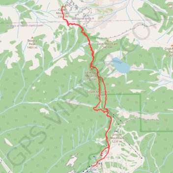
Import a GPX file

Crown Mountain

Lynn Headwaters Regional Park. #Hiking #Loop #Crown #Lynn

  • Distance: 6.1 mi
  • Elevation gain: 896 m
  • Maximum elevation: 1,468 m
  • Elevation loss: 892 m
  • Minimum elevation: 1,082 m

Interactive trail map

Trail profile

  • Distance: 6.1 mi
  • Elevation gain: 896 m
  • Maximum elevation: 1,468 m
  • Elevation loss: 892 m
  • Minimum elevation: 1,082 m

About this trail

Other hiking, mountain biking, running and outdoor activity trails

Click on a trail to view its statistics, map and profile.

Hanes Valley Loop

Canada > British Columbia > Metro Vancouver Regional District

Lynn Headwaters Regional Park. #Hiking #Loop #Hanes #Lynn

Distance: 15.3 mi • Elevation gain: 1,327 m • Maximum elevation: 1,293 m

Vancouver - Golden

Canada > British Columbia > Metro Vancouver Regional District > Vancouver

#Bike #Vancouver #Golden

Distance: 514.2 mi • Elevation gain: 9,376 m • Maximum elevation: 1,347 m

Gear up for your next adventure:

🥾Men's Waterproof Hiking Boots - Durable footwear with deep lugs for muddy and rocky UK terrains
📕Outdoor Navigation Books - Learn traditional and modern navigation techniques
🥾Women's Waterproof Hiking Boots - High-performance trekking boots designed for all-weather comfort
🧴Tick Removal Tools - Small, essential health tool for UK woodland and moorland
🌦️Portable Weather Meters - Handheld tools for monitoring weather conditions

As an Amazon Associate, this site earns from qualifying purchases at no extra cost to you.