Import a GPX file

Hartwood Acres Loop Trails

  • Distance: 4.0 mi
  • Elevation gain: 146 m
  • Maximum elevation: 397 m
  • Elevation loss: 148 m
  • Minimum elevation: 328 m
  • Moving time: 1 h 24 m
  • Moving speed: 2.8 mph
  • Maximum speed: 6.5 mph
  • Total time: 1 h 25 m
  • Global speed: 2.8 mph

Interactive trail map

Trail profile

  • Distance: 4.0 mi
  • Elevation gain: 146 m
  • Maximum elevation: 397 m
  • Elevation loss: 148 m
  • Minimum elevation: 328 m
  • Moving time: 1 h 24 m
  • Moving speed: 2.8 mph
  • Maximum speed: 6.5 mph
  • Total time: 1 h 25 m
  • Global speed: 2.8 mph

About this trail

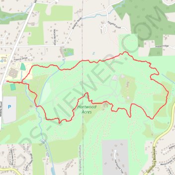
Name: Hartwood Acres Loop Trails trail, distance, elevation, map, profile, GPS track

Start: Middle Road, Hampton Township, Allegheny County, Pennsylvania, 15116, United States (40.57048 -79.92715)

End: Hartwood Acres, Hampton Township, Allegheny County, Pennsylvania, 15101, United States (40.57034 -79.92613)

Coordinates: 40.56573 -79.92715 40.57388 -79.90291

Gear up for your next adventure:

🔦LED Camping Lanterns - Illumination for reading maps inside your tent at night
🔋Lithium AA Batteries - Long-lasting power that performs well in cold mountain weather
🧼Biodegradable Soap - Leave-no-trace hygiene for multi-day mountain treks
📐Altimeters & Barometers - Tools for measuring altitude and air pressure
📱Rugged Phone Cases - Heavy-duty protection for smartphones used as secondary GPS tools

As an Amazon Associate, this site earns from qualifying purchases at no extra cost to you.