Ascent of Voltage Peak in snow conditions
Scrambling, mountain, peak
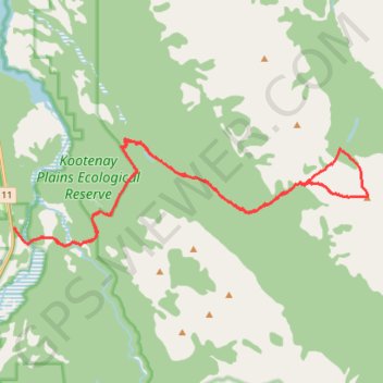
- Distance: 18.5 mi
- Elevation gain: 1,525 m
- Maximum elevation: 2,686 m
- Elevation loss: 1,526 m
- Minimum elevation: 1,332 m
- Moving time: 8 h 58 m
- Moving speed: 2.1 mph
- Maximum speed: 4.2 mph
- Total time: 13 h 31 m
- Global speed: 1.4 mph
Interactive trail map
Trail profile
- Distance: 18.5 mi
- Elevation gain: 1,525 m
- Maximum elevation: 2,686 m
- Elevation loss: 1,526 m
- Minimum elevation: 1,332 m
- Moving time: 8 h 58 m
- Moving speed: 2.1 mph
- Maximum speed: 4.2 mph
- Total time: 13 h 31 m
- Global speed: 1.4 mph
About this trail
Name: Ascent of Voltage Peak in snow conditions trail, distance, elevation, map, profile, GPS track
Coordinates: 52.04721 -116.41219 52.07200 -116.28196
Other hiking, mountain biking, running and outdoor activity trails
Click on a trail to view its statistics, map and profile.
Mount William Booth ascent
Canada > Alberta > Clearwater County
Scrambling, mountain, peak
Distance: 14.3 mi • Elevation gain: 1,506 m • Maximum elevation: 2,698 m
Ardennes Peak, Normandy Peak and Stan Waters Peak Traverse
Canada > Alberta > Clearwater County
Scrambling, mountain, peak
Distance: 11.0 mi • Elevation gain: 1,590 m • Maximum elevation: 2,479 m
Siffleur Falls Trail
Canada > Alberta > Clearwater County
Kootenay Plains Ecological Reserve. #Hiking #Snowshoeing #River #Falls #Forest
Distance: 6.0 mi • Elevation gain: 189 m • Maximum elevation: 1,427 m