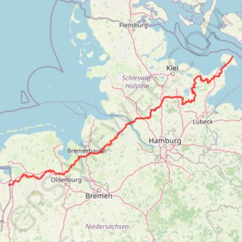
TET-Germany-Section1-20210518
- Distance: 297.9 mi
- Elevation gain: 1,685 m
- Maximum elevation: 127 m
- Elevation loss: 1,686 m
- Minimum elevation: -2 m
Interactive trail map
Trail profile
- Distance: 297.9 mi
- Elevation gain: 1,685 m
- Maximum elevation: 127 m
- Elevation loss: 1,686 m
- Minimum elevation: -2 m
About this trail
Name: TET-Germany-Section1-20210518 trail, distance, elevation, map, profile, GPS track
Start: E 47, Puttgarden, Fehmarn, Ostholstein, Schleswig-Holstein, 23769, Germany (54.50146 11.22468)
Coordinates: 53.12306 7.18201 54.50146 11.22468
Other hiking, mountain biking, running and outdoor activity trails
Click on a trail to view its statistics, map and profile.
SVD_Tour_17_Neue_Streckenführung
Germany > Lower Saxony > Heidekreis > Schneverdingen > Hansahlen
Distance: 16.4 mi • Elevation gain: 118 m • Maximum elevation: 116 m
PT23BS1 Kiel → Lörrach
Germany > Schleswig-Holstein > Kiel
Distance: 650.4 mi • Elevation gain: 9,265 m • Maximum elevation: 757 m
Marina am Stau
Germany > Schleswig-Holstein > Lübeck
Distance: 23.6 mi • Elevation gain: 13 m • Maximum elevation: 1 m