Make a donation
Gear up for your next adventure:
As an Amazon Associate, this site earns from qualifying purchases at no extra cost to you.
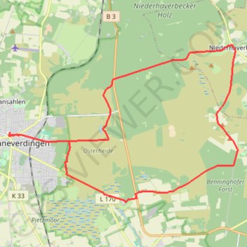
SVD_Tour_17_Neue_Streckenführung
- Distance: 16.4 mi
- Elevation gain: 118 m
- Maximum elevation: 116 m
- Elevation loss: 118 m
- Minimum elevation: 79 m
Interactive trail map
Make a donation
Gear up for your next adventure:
As an Amazon Associate, this site earns from qualifying purchases at no extra cost to you.
Trail profile
- Distance: 16.4 mi
- Elevation gain: 118 m
- Maximum elevation: 116 m
- Elevation loss: 118 m
- Minimum elevation: 79 m
Make a donation
Gear up for your next adventure:
As an Amazon Associate, this site earns from qualifying purchases at no extra cost to you.
About this trail
Name: SVD_Tour_17_Neue_Streckenführung trail, distance, elevation, map, profile, GPS track
Coordinates: 53.09718 9.78749 53.14869 9.91236
Make a donation
Gear up for your next adventure:
As an Amazon Associate, this site earns from qualifying purchases at no extra cost to you.
Other hiking, mountain biking, running and outdoor activity trails
Click on a trail to view its statistics, map and profile.
PT23BS1 Kiel → Lörrach
Germany > Schleswig-Holstein > Kiel
Distance: 650.4 mi • Elevation gain: 9,265 m • Maximum elevation: 757 m
TET-Germany-Section1-20210518
Germany > Schleswig-Holstein > Ostholstein > Fehmarn > Puttgarden
Distance: 297.9 mi • Elevation gain: 1,685 m • Maximum elevation: 127 m