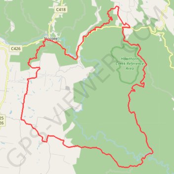
Noojee - Vesper - Neerim East - Noojee
Loop, MTB, Gravel
- Distance: 31.1 mi
- Elevation gain: 1,330 m
- Maximum elevation: 559 m
- Elevation loss: 1,332 m
- Minimum elevation: 162 m
- Moving time: 2 h 35 m
- Moving speed: 12.0 mph
- Maximum speed: 31.5 mph
- Total time: 2 h 37 m
- Global speed: 11.9 mph
Interactive trail map
Trail profile
- Distance: 31.1 mi
- Elevation gain: 1,330 m
- Maximum elevation: 559 m
- Elevation loss: 1,332 m
- Minimum elevation: 162 m
- Moving time: 2 h 35 m
- Moving speed: 12.0 mph
- Maximum speed: 31.5 mph
- Total time: 2 h 37 m
- Global speed: 11.9 mph
About this trail
Name: Noojee - Vesper - Neerim East - Noojee trail, distance, elevation, map, profile, GPS track
Start: 27, Matthew Street, Noojee, Shire of Baw Baw, Victoria, 3833, Australia (-37.89657 146.00484)
End: 26, Matthew Street, Noojee, Shire of Baw Baw, Victoria, 3833, Australia (-37.89650 146.00496)
Coordinates: -37.98051 145.97502 -37.87227 146.08723
Other hiking, mountain biking, running and outdoor activity trails
Click on a trail to view its statistics, map and profile.
Ridge Road Loch Valley Loop
Distance: 8.7 mi • Elevation gain: 408 m • Maximum elevation: 545 m