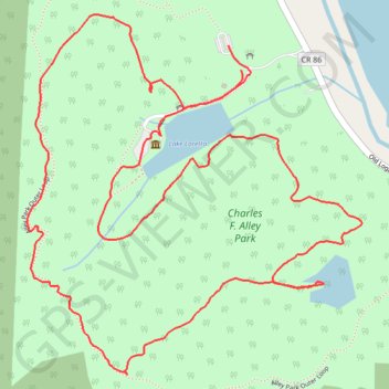
Charles F. Alley Park Loop
Loop hike from Lake Loretta via Alley Park Outer Loop, Twin Lake and George Hutchins Covered Bridge in the Alley Park. #Hiking #Loop #Nature #Lake #Forest #Park
- Distance: 3.0 mi
- Elevation gain: 145 m
- Maximum elevation: 326 m
- Elevation loss: 146 m
- Minimum elevation: 255 m
- Moving time: 1 h 15 m
- Moving speed: 2.4 mph
- Maximum speed: 7.9 mph
- Total time: 1 h 23 m
- Global speed: 2.2 mph
Interactive trail map
Trail profile
- Distance: 3.0 mi
- Elevation gain: 145 m
- Maximum elevation: 326 m
- Elevation loss: 146 m
- Minimum elevation: 255 m
- Moving time: 1 h 15 m
- Moving speed: 2.4 mph
- Maximum speed: 7.9 mph
- Total time: 1 h 23 m
- Global speed: 2.2 mph
About this trail
Name: Charles F. Alley Park Loop trail, distance, elevation, map, profile, GPS track
Coordinates: 39.67463 -82.58312 39.68308 -82.57291
Other hiking, mountain biking, running and outdoor activity trails
Click on a trail to view its statistics, map and profile.
Alley Park trails
United States > Ohio > Fairfield County > Lancaster > Whites
Distance: 2.0 mi • Elevation gain: 109 m • Maximum elevation: 303 m