Alley Park trails
- Distance: 2.0 mi
- Elevation gain: 109 m
- Maximum elevation: 303 m
- Elevation loss: 109 m
- Minimum elevation: 256 m
- Moving time: 41 m 26 s
- Moving speed: 2.8 mph
- Maximum speed: 5.5 mph
- Total time: 47 m 50 s
- Global speed: 2.5 mph
Interactive trail map
Trail profile
- Distance: 2.0 mi
- Elevation gain: 109 m
- Maximum elevation: 303 m
- Elevation loss: 109 m
- Minimum elevation: 256 m
- Moving time: 41 m 26 s
- Moving speed: 2.8 mph
- Maximum speed: 5.5 mph
- Total time: 47 m 50 s
- Global speed: 2.5 mph
About this trail
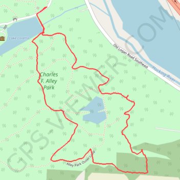
Name: Alley Park trails trail, distance, elevation, map, profile, GPS track
Coordinates: 39.67397 -82.57744 39.68147 -82.57067
Other hiking, mountain biking, running and outdoor activity trails
Click on a trail to view its statistics, map and profile.