Import a GPX file

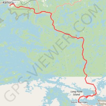
Kenora - Sioux Narrows

#Bike #Kenora #Sioux

  • Distance: 48.3 mi
  • Elevation gain: 681 m
  • Maximum elevation: 397 m
  • Elevation loss: 686 m
  • Minimum elevation: 324 m

Interactive trail map

Trail profile

  • Distance: 48.3 mi
  • Elevation gain: 681 m
  • Maximum elevation: 397 m
  • Elevation loss: 686 m
  • Minimum elevation: 324 m

About this trail

Other hiking, mountain biking, running and outdoor activity trails

Click on a trail to view its statistics, map and profile.

Sioux Narrows - Nestor Falls

Canada > Ontario > Kenora District > Sioux Narrows-Nestor Falls Township

#Bike #Sioux #Nestor

Distance: 36.1 mi • Elevation gain: 597 m • Maximum elevation: 403 m

Whiteshell - Kenora

Canada > Unorganized Division No. 1

#Bike #Whiteshell #Kenora

Distance: 43.0 mi • Elevation gain: 577 m • Maximum elevation: 382 m

Kenora - Vermilion Bay

Canada > Ontario > Kenora District > Kenora

#Bike #Kenora #VermilionBay

Distance: 54.1 mi • Elevation gain: 894 m • Maximum elevation: 452 m

Gear up for your next adventure:

🗺️Scratch-off Peak Maps - Track your progress climbing Munros or Wainwrights
🍲Portable Camping Stoves - Fast-boiling stoves for hot meals on remote topographic survey trips
📻Hand-Crank Emergency Radios - Stay updated on weather warnings in remote areas
👖Convertible Hiking Trousers - Versatile zip-off pants for changing mountain weather conditions
🎒Backpack Rain Covers - Universal waterproof covers to protect your gear from downpours

As an Amazon Associate, this site earns from qualifying purchases at no extra cost to you.