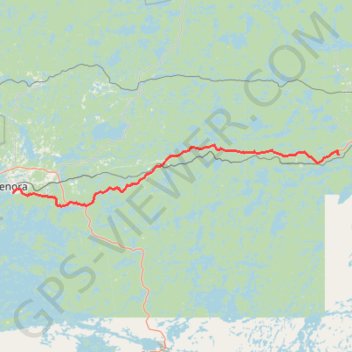
Kenora - Vermilion Bay
- Distance: 54.1 mi
- Elevation gain: 894 m
- Maximum elevation: 452 m
- Elevation loss: 848 m
- Minimum elevation: 328 m
Interactive trail map
Trail profile
- Distance: 54.1 mi
- Elevation gain: 894 m
- Maximum elevation: 452 m
- Elevation loss: 848 m
- Minimum elevation: 328 m
About this trail
Name: Kenora - Vermilion Bay trail, distance, elevation, map, profile, GPS track
Coordinates: 49.72574 -94.47968 49.84955 -93.45663
Other hiking, mountain biking, running and outdoor activity trails
Click on a trail to view its statistics, map and profile.
Whiteshell - Kenora
Canada > Unorganized Division No. 1
#Bike #Whiteshell #Kenora
Distance: 43.0 mi • Elevation gain: 577 m • Maximum elevation: 382 m
Vermilion Bay - Dryden
Canada > Ontario > Kenora District > Machin Township
Distance: 32.5 mi • Elevation gain: 308 m • Maximum elevation: 406 m