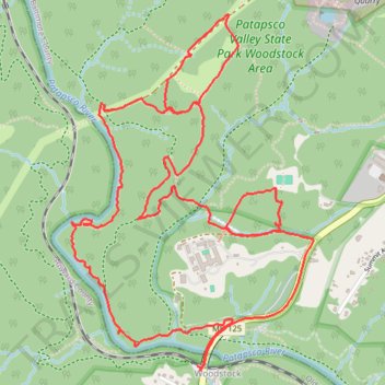
Patapsco Valley State Park - Woodstock Area
- Distance: 5.0 mi
- Elevation gain: 157 m
- Maximum elevation: 141 m
- Elevation loss: 157 m
- Minimum elevation: 77 m
- Moving time: 1 h 16 m
- Moving speed: 3.9 mph
- Maximum speed: 8.7 mph
- Total time: 1 h 16 m
- Global speed: 3.9 mph
Interactive trail map
Trail profile
- Distance: 5.0 mi
- Elevation gain: 157 m
- Maximum elevation: 141 m
- Elevation loss: 157 m
- Minimum elevation: 77 m
- Moving time: 1 h 16 m
- Moving speed: 3.9 mph
- Maximum speed: 8.7 mph
- Total time: 1 h 16 m
- Global speed: 3.9 mph
About this trail
Name: Patapsco Valley State Park - Woodstock Area trail, distance, elevation, map, profile, GPS track
Coordinates: 39.33092 -76.87729 39.34536 -76.86453
Other hiking, mountain biking, running and outdoor activity trails
Click on a trail to view its statistics, map and profile.
Patapsco Valley State Park Loop
United States > Maryland > Howard County > Ellicott City
Morning Ride
Distance: 16.6 mi • Elevation gain: 526 m • Maximum elevation: 158 m