Thank you for supporting this site ❤️
Make a donation
Make a donation
Gear up for your next adventure:
As an Amazon Associate, this site earns from qualifying purchases at no extra cost to you.
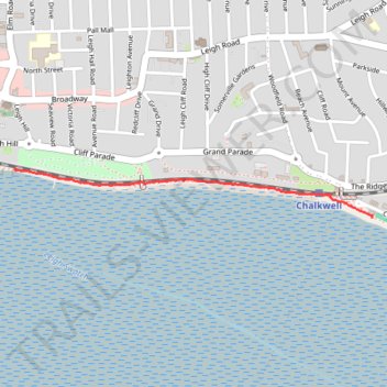
Cinder Path, Leigh on Sea
- Distance: 0.8 mi
- Elevation gain: 7 m
- Maximum elevation: 6 m
- Elevation loss: 7 m
- Minimum elevation: 0 m
- Moving time: 20 m 8 s
- Moving speed: 2.4 mph
- Maximum speed: 3.6 mph
- Total time: 20 m 8 s
- Global speed: 2.4 mph
Interactive trail map
Thank you for supporting this site ❤️
Make a donation
Make a donation
Gear up for your next adventure:
As an Amazon Associate, this site earns from qualifying purchases at no extra cost to you.
Trail profile
- Distance: 0.8 mi
- Elevation gain: 7 m
- Maximum elevation: 6 m
- Elevation loss: 7 m
- Minimum elevation: 0 m
- Moving time: 20 m 8 s
- Moving speed: 2.4 mph
- Maximum speed: 3.6 mph
- Total time: 20 m 8 s
- Global speed: 2.4 mph
Thank you for supporting this site ❤️
Make a donation
Make a donation
Gear up for your next adventure:
As an Amazon Associate, this site earns from qualifying purchases at no extra cost to you.
About this trail
Name: Cinder Path, Leigh on Sea trail, distance, elevation, map, profile, GPS track
Coordinates: 51.53783 0.65461 51.53934 0.67256
Topography: Southend-on-Sea topographic map, elevation, terrain
Thank you for supporting this site ❤️
Make a donation
Make a donation
Gear up for your next adventure:
As an Amazon Associate, this site earns from qualifying purchases at no extra cost to you.