Mount Uniacke Trail
Loop hike from Uniacke Lake via Clarke Lake and Thompson Lake. #Hiking #Loop #Nature #Forest #Lake
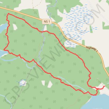
- Distance: 4.7 mi
- Elevation gain: 94 m
- Maximum elevation: 191 m
- Elevation loss: 93 m
- Minimum elevation: 156 m
- Moving time: 2 h 2 m
- Moving speed: 2.3 mph
- Maximum speed: 16.4 mph
- Total time: 2 h 34 m
- Global speed: 1.8 mph
Interactive trail map
Trail profile
- Distance: 4.7 mi
- Elevation gain: 94 m
- Maximum elevation: 191 m
- Elevation loss: 93 m
- Minimum elevation: 156 m
- Moving time: 2 h 2 m
- Moving speed: 2.3 mph
- Maximum speed: 16.4 mph
- Total time: 2 h 34 m
- Global speed: 1.8 mph
About this trail
Name: Mount Uniacke Trail trail, distance, elevation, map, profile, GPS track
Coordinates: 44.90037 -63.87358 44.91737 -63.84391
Other hiking, mountain biking, running and outdoor activity trails
Click on a trail to view its statistics, map and profile.
Mount Uniack Estate - Wilderness Loop
Canada > Nova Scotia > Hants County > Mount Uniacke
Distance: 4.5 mi • Elevation gain: 89 m • Maximum elevation: 191 m
Red Spruce Trail
Canada > Nova Scotia > Hants County > Mount Uniacke
Distance: 1.7 mi • Elevation gain: 50 m • Maximum elevation: 193 m