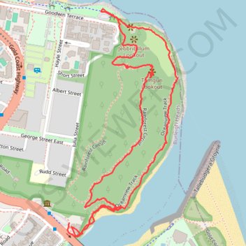
Burleigh Head National Park - Tumgun Lookout
- Distance: 2.0 mi
- Elevation gain: 122 m
- Maximum elevation: 71 m
- Elevation loss: 127 m
- Minimum elevation: 2 m
- Moving time: 56 m 29 s
- Moving speed: 2.1 mph
- Maximum speed: 9.7 mph
- Total time: 1 h 14 m
- Global speed: 1.6 mph
Interactive trail map
Trail profile
- Distance: 2.0 mi
- Elevation gain: 122 m
- Maximum elevation: 71 m
- Elevation loss: 127 m
- Minimum elevation: 2 m
- Moving time: 56 m 29 s
- Moving speed: 2.1 mph
- Maximum speed: 9.7 mph
- Total time: 1 h 14 m
- Global speed: 1.6 mph
About this trail
Name: Burleigh Head National Park - Tumgun Lookout trail, distance, elevation, map, profile, GPS track
Coordinates: -28.09769 153.45596 -28.08981 153.46030
Other hiking, mountain biking, running and outdoor activity trails
Click on a trail to view its statistics, map and profile.
Gold Coast - Coolangatta
Australia > Queensland > Gold Coast City
#Bike
Distance: 18.3 mi • Elevation gain: 196 m • Maximum elevation: 28 m