Surf Coast Walk
Bass Strait. #Hiking
- Distance: 21.1 mi
- Elevation gain: 607 m
- Maximum elevation: 111 m
- Elevation loss: 607 m
- Minimum elevation: 0 m
- Moving time: 6 h 20 m
- Moving speed: 3.3 mph
- Maximum speed: 7.0 mph
- Total time: 7 h 9 m
- Global speed: 3.0 mph
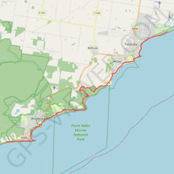
Interactive trail map
Trail profile
- Distance: 21.1 mi
- Elevation gain: 607 m
- Maximum elevation: 111 m
- Elevation loss: 607 m
- Minimum elevation: 0 m
- Moving time: 6 h 20 m
- Moving speed: 3.3 mph
- Maximum speed: 7.0 mph
- Total time: 7 h 9 m
- Global speed: 3.0 mph
About this trail
Name: Surf Coast Walk trail, distance, elevation, map, profile, GPS track
Start: The Esplanade, Torquay, Surf Coast Shire, Victoria, 3228, Australia (-38.31381 144.36296)
End: Surf Coast Walk, Anglesea, Surf Coast Shire, Victoria, 3230, Australia (-38.43071 144.14627)
Coordinates: -38.43071 144.14627 -38.31381 144.36296
Other hiking, mountain biking, running and outdoor activity trails
Click on a trail to view its statistics, map and profile.
Anglesea - Aireys Inlet
Australia > Victoria > Anglesea
Great Otway National Park. #Hiking #Loop #GreatOtway
Distance: 15.4 mi • Elevation gain: 462 m • Maximum elevation: 99 m
Loop Trail Run in Great Otway National Park
Australia > Victoria > Anglesea
Distance: 6.4 mi • Elevation gain: 188 m • Maximum elevation: 117 m