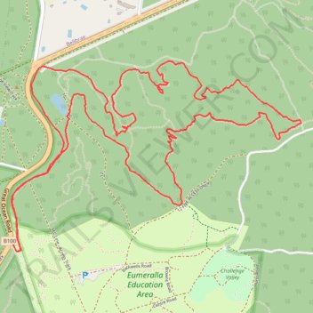
Loop Trail Run in Great Otway National Park
- Distance: 6.4 mi
- Elevation gain: 188 m
- Maximum elevation: 117 m
- Elevation loss: 192 m
- Minimum elevation: 69 m
- Moving time: 1 h 26 m
- Moving speed: 4.5 mph
- Maximum speed: 6.9 mph
- Total time: 1 h 27 m
- Global speed: 4.4 mph
Interactive trail map
Trail profile
- Distance: 6.4 mi
- Elevation gain: 188 m
- Maximum elevation: 117 m
- Elevation loss: 192 m
- Minimum elevation: 69 m
- Moving time: 1 h 26 m
- Moving speed: 4.5 mph
- Maximum speed: 6.9 mph
- Total time: 1 h 27 m
- Global speed: 4.4 mph
About this trail
Name: Loop Trail Run in Great Otway National Park trail, distance, elevation, map, profile, GPS track
Start: 14 Scout Camp Link, Anglesea, Surf Coast Shire, Victoria, 3230, Australia (-38.39198 144.20533)
End: Hurst Road, Anglesea, Surf Coast Shire, Victoria, 3230, Australia (-38.39155 144.20511)
Coordinates: -38.39198 144.20497 -38.38000 144.22823
Other hiking, mountain biking, running and outdoor activity trails
Click on a trail to view its statistics, map and profile.
Surf Coast Walk
Australia > Victoria > Torquay
Bass Strait. #Hiking
Distance: 21.1 mi • Elevation gain: 607 m • Maximum elevation: 111 m