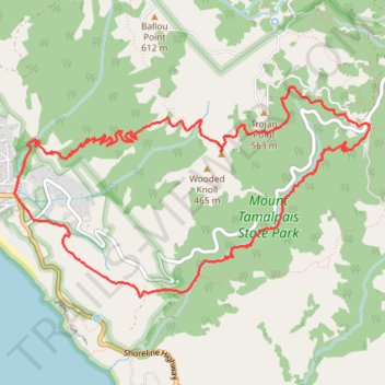
Dipsea Trail, Steep Ravine Trail and Matt Davis Trail Loop in Mount Tamalpais State Park
The Dipsea Trail, Steep Ravine Trail, and Matt Davis Trail Loop in Mount Tamalpais State Park offers hikers a diverse experience, beginning at Stinson Beach and ascending through coastal hills with expansive ocean vistas. The route transitions into a dense redwood forest alongside Webb Creek, featuring cascading waterfalls, wooden bridges, and a notable wooden ladder ascent. Upon reaching the Pantoll Ranger Station, the trail descends through open meadows and forested areas, providing panoramic views of the Pacific Ocean before returning to the beach. #Hiking #Loop #Mountain #Sea #Pacific #Ocean #Forest #Nature #Overlook
- Distance: 7.4 mi
- Elevation gain: 702 m
- Maximum elevation: 496 m
- Elevation loss: 704 m
- Minimum elevation: 13 m
- Moving time: 3 h 29 m
- Moving speed: 2.1 mph
- Maximum speed: 14.1 mph
- Total time: 4 h 10 m
- Global speed: 1.8 mph
Interactive trail map
Trail profile
- Distance: 7.4 mi
- Elevation gain: 702 m
- Maximum elevation: 496 m
- Elevation loss: 704 m
- Minimum elevation: 13 m
- Moving time: 3 h 29 m
- Moving speed: 2.1 mph
- Maximum speed: 14.1 mph
- Total time: 4 h 10 m
- Global speed: 1.8 mph
About this trail
Name: Dipsea Trail, Steep Ravine Trail and Matt Davis Trail Loop in Mount Tamalpais State Park trail, distance, elevation, map, profile, GPS track
Start: Dipsea Trail, Stinson Beach, Marin County, California, 94970, United States (37.89658 -122.63595)
End: Panoramic Highway, Marin County, California, 94970, United States (37.89667 -122.63606)
Coordinates: 37.89074 -122.63772 37.90659 -122.60388
Other hiking, mountain biking, running and outdoor activity trails
Click on a trail to view its statistics, map and profile.
Old Mine, Dipsea and Steep Ravine Trails Loop in Mount Tamalpais State Park
United States > California > Marin County
The Old Mine, Dipsea, and Steep Ravine Trails Loop in Mount Tamalpais State Park offers hikers a diverse experience, featuring towering redwood forests, cascading waterfalls, and panoramic views of the Pacific Ocean. Along the route, one can traverse lush fern-lined paths, navigate wooden ladders beside Webb…
Distance: 3.9 mi • Elevation gain: 310 m • Maximum elevation: 459 m
Point Reyes Loop
United States > California > Marin County > Mill Valley
Distance: 62.3 mi • Elevation gain: 1,900 m • Maximum elevation: 236 m