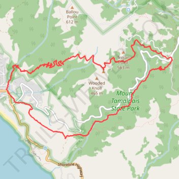
Matt Davis Trail, Dipsea Trail and Steep Ravine Trail Loop
Interactive trail map
Trail profile
- Distance: 7.0 mi
- Elevation gain: 698 m
- Maximum elevation: 497 m
- Elevation loss: 699 m
- Minimum elevation: 13 m
- Moving time: 3 h 12 m
- Moving speed: 2.2 mph
- Maximum speed: 10.5 mph
- Total time: 3 h 29 m
- Global speed: 2.0 mph
About this trail
Name: Matt Davis Trail, Dipsea Trail and Steep Ravine Trail Loop trail, distance, elevation, map, profile, GPS track
Coordinates: 37.89076 -122.63769 37.90659 -122.60406
Other hiking, mountain biking, running and outdoor activity trails
Click on a trail to view its statistics, map and profile.
Old Mine, Dipsea and Steep Ravine Trails Loop in Mount Tamalpais State Park
United States > California > Marin County
The Old Mine, Dipsea, and Steep Ravine Trails Loop in Mount Tamalpais State Park offers hikers a diverse experience, featuring towering redwood forests, cascading waterfalls, and panoramic views of the Pacific Ocean. Along the route, one can traverse lush fern-lined paths, navigate wooden ladders beside Webb…
Distance: 3.9 mi • Elevation gain: 310 m • Maximum elevation: 459 m
Dipsea Trail, Steep Ravine Trail and Matt Davis Trail Loop in Mount Tamalpais State Park
United States > California > Marin County > Stinson Beach
The Dipsea Trail, Steep Ravine Trail, and Matt Davis Trail Loop in Mount Tamalpais State Park offers hikers a diverse experience, beginning at Stinson Beach and ascending through coastal hills with expansive ocean vistas. The route transitions into a dense redwood forest alongside Webb Creek, featuring…
Distance: 7.4 mi • Elevation gain: 702 m • Maximum elevation: 496 m
Point Reyes Loop
United States > California > Marin County > Mill Valley
Distance: 62.3 mi • Elevation gain: 1,900 m • Maximum elevation: 236 m