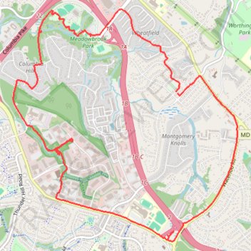
Ellicott City - Meadowbrook Park
- Distance: 7.5 mi
- Elevation gain: 103 m
- Maximum elevation: 160 m
- Elevation loss: 102 m
- Minimum elevation: 106 m
- Moving time: 1 h 29 m
- Moving speed: 5.1 mph
- Maximum speed: 8.8 mph
- Total time: 1 h 31 m
- Global speed: 4.9 mph
Interactive trail map
Trail profile
- Distance: 7.5 mi
- Elevation gain: 103 m
- Maximum elevation: 160 m
- Elevation loss: 102 m
- Minimum elevation: 106 m
- Moving time: 1 h 29 m
- Moving speed: 5.1 mph
- Maximum speed: 8.8 mph
- Total time: 1 h 31 m
- Global speed: 4.9 mph
About this trail
Name: Ellicott City - Meadowbrook Park trail, distance, elevation, map, profile, GPS track
Coordinates: 39.22280 -76.83128 39.24930 -76.79822
Other hiking, mountain biking, running and outdoor activity trails
Click on a trail to view its statistics, map and profile.
Ellicott City - Meadowbrook Park Loop
United States > Maryland > Howard County > Ellicott City
Distance: 4.0 mi • Elevation gain: 61 m • Maximum elevation: 133 m
Patapsco Valley State Park - Ellicott City
United States > Maryland > Howard County > Ellicott City
Distance: 7.9 mi • Elevation gain: 256 m • Maximum elevation: 148 m