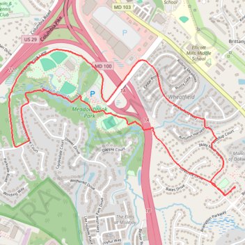
Ellicott City - Meadowbrook Park Loop
- Distance: 4.0 mi
- Elevation gain: 61 m
- Maximum elevation: 133 m
- Elevation loss: 60 m
- Minimum elevation: 106 m
- Moving time: 50 m 58 s
- Moving speed: 4.7 mph
- Maximum speed: 9.4 mph
- Total time: 50 m 58 s
- Global speed: 4.7 mph
Interactive trail map
Trail profile
- Distance: 4.0 mi
- Elevation gain: 61 m
- Maximum elevation: 133 m
- Elevation loss: 60 m
- Minimum elevation: 106 m
- Moving time: 50 m 58 s
- Moving speed: 4.7 mph
- Maximum speed: 9.4 mph
- Total time: 50 m 58 s
- Global speed: 4.7 mph
About this trail
Name: Ellicott City - Meadowbrook Park Loop trail, distance, elevation, map, profile, GPS track
Coordinates: 39.23966 -76.82763 39.25005 -76.80680
Other hiking, mountain biking, running and outdoor activity trails
Click on a trail to view its statistics, map and profile.
Ellicott City - Meadowbrook Park
United States > Maryland > Howard County > Ellicott City
Distance: 7.5 mi • Elevation gain: 103 m • Maximum elevation: 160 m
Patapsco Valley State Park - Ellicott City
United States > Maryland > Howard County > Ellicott City
Distance: 7.9 mi • Elevation gain: 256 m • Maximum elevation: 148 m