Make a donation
Gear up for your next adventure:
As an Amazon Associate, this site earns from qualifying purchases at no extra cost to you.
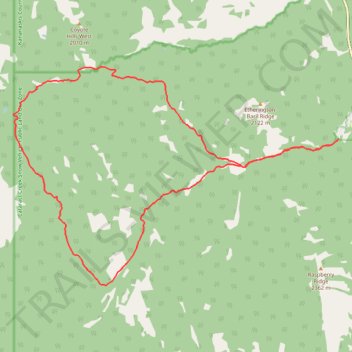
Etherington Creek, Great Divide, Baril Creek, Baril Loop
- Distance: 13.7 mi
- Elevation gain: 617 m
- Maximum elevation: 2,073 m
- Elevation loss: 617 m
- Minimum elevation: 1,651 m
- Moving time: 4 h 30 m
- Moving speed: 3.0 mph
- Maximum speed: 5.1 mph
- Total time: 5 h 24 m
- Global speed: 2.5 mph
Interactive trail map
Make a donation
Gear up for your next adventure:
As an Amazon Associate, this site earns from qualifying purchases at no extra cost to you.
Trail profile
- Distance: 13.7 mi
- Elevation gain: 617 m
- Maximum elevation: 2,073 m
- Elevation loss: 617 m
- Minimum elevation: 1,651 m
- Moving time: 4 h 30 m
- Moving speed: 3.0 mph
- Maximum speed: 5.1 mph
- Total time: 5 h 24 m
- Global speed: 2.5 mph
Make a donation
Gear up for your next adventure:
As an Amazon Associate, this site earns from qualifying purchases at no extra cost to you.
About this trail
Name: Etherington Creek, Great Divide, Baril Creek, Baril Loop trail, distance, elevation, map, profile, GPS track
Start: Kananaskis Improvement District, Alberta, Canada (50.32554 -114.63381)
End: Kananaskis Improvement District, Alberta, Canada (50.32568 -114.63369)
Coordinates: 50.29643 -114.73533 50.33996 -114.63369
Make a donation
Gear up for your next adventure:
As an Amazon Associate, this site earns from qualifying purchases at no extra cost to you.
Other hiking, mountain biking, running and outdoor activity trails
Click on a trail to view its statistics, map and profile.
Fording River Pass Trail from Etherington Campground
Canada > Alberta > Kananaskis Improvement District
Distance: 19.1 mi • Elevation gain: 1,068 m • Maximum elevation: 2,321 m