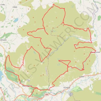
Blencathra, Knott and Skiddaw loop
- Distance: 48.3 mi
- Elevation gain: 4,362 m
- Maximum elevation: 922 m
- Elevation loss: 4,361 m
- Minimum elevation: 90 m
Interactive trail map
Trail profile
- Distance: 48.3 mi
- Elevation gain: 4,362 m
- Maximum elevation: 922 m
- Elevation loss: 4,361 m
- Minimum elevation: 90 m
About this trail
Name: Blencathra, Knott and Skiddaw loop trail, distance, elevation, map, profile, GPS track
Start: Brundholme Road, Keswick, Cumberland, England, CA12 5PN, United Kingdom (54.60700 -3.13611)
End: Brundholme Road, Keswick, Cumberland, England, CA12 5PN, United Kingdom (54.60699 -3.13587)
Coordinates: 54.60690 -3.18715 54.72556 -2.98774
Topography: Cumberland topographic map, elevation, terrain
Other hiking, mountain biking, running and outdoor activity trails
Click on a trail to view its statistics, map and profile.
Blencathra hike
United Kingdom > England > Westmorland and Furness > Scales
Distance: 5.2 mi • Elevation gain: 632 m • Maximum elevation: 854 m
Blencathra and local peaks
United Kingdom > England > Westmorland and Furness > Scales > Guardhouse
Hike
Distance: 8.8 mi • Elevation gain: 873 m • Maximum elevation: 854 m
Hillwalk Skiddaw
United Kingdom > England > Cumberland > Bassenthwaite
Hillwalk, Skiddaw
Distance: 7.6 mi • Elevation gain: 881 m • Maximum elevation: 922 m
Latrigg Loop
United Kingdom > England > Cumberland > Keswick > Old Windlebrowe
Distance: 5.4 mi • Elevation gain: 252 m • Maximum elevation: 308 m