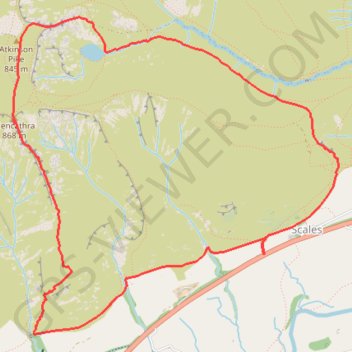
Blencathra - Lake District National Park
Interactive trail map
Trail profile
- Distance: 5.1 mi
- Elevation gain: 684 m
- Maximum elevation: 851 m
- Elevation loss: 684 m
- Minimum elevation: 223 m
About this trail
Name: Blencathra - Lake District National Park trail, distance, elevation, map, profile, GPS track
Coordinates: 54.62680 -3.04983 54.64598 -3.01587
Topography: Westmorland and Furness topographic map, elevation, terrain
Other hiking, mountain biking, running and outdoor activity trails
Click on a trail to view its statistics, map and profile.
Blencathra hike
United Kingdom > England > Westmorland and Furness > Scales
Distance: 5.2 mi • Elevation gain: 632 m • Maximum elevation: 854 m
Blencathra, Knott and Skiddaw loop
United Kingdom > England > Cumberland > Keswick
Distance: 48.3 mi • Elevation gain: 4,362 m • Maximum elevation: 922 m
Blencathra and local peaks
United Kingdom > England > Westmorland and Furness > Scales > Guardhouse
Hike
Distance: 8.8 mi • Elevation gain: 873 m • Maximum elevation: 854 m