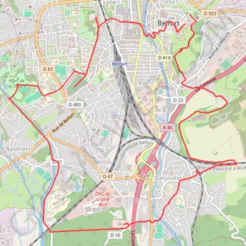
Circuit du siège de Belfort
name=Circuit du siège de Belfort
- Distance: 9.0 mi
- Elevation gain: 190 m
- Maximum elevation: 409 m
- Elevation loss: 202 m
- Minimum elevation: 347 m
Interactive trail map
Trail profile
- Distance: 9.0 mi
- Elevation gain: 190 m
- Maximum elevation: 409 m
- Elevation loss: 202 m
- Minimum elevation: 347 m
About this trail
Name: Circuit du siège de Belfort trail, distance, elevation, map, profile, GPS track
Coordinates: 47.61155 6.83314 47.63912 6.87580
Other hiking, mountain biking, running and outdoor activity trails
Click on a trail to view its statistics, map and profile.
PT23DS2 Lörrach → Cadaqués
Germany > Baden-Württemberg > Landkreis Lörrach > Lörrach (Kernstadt)
Distance: 652.9 mi • Elevation gain: 13,130 m • Maximum elevation: 1,505 m
Track vom: 2020-06-13 07:00
Germany > North Rhine-Westphalia > Kreis Wesel > Schermbeck
Distance: 422.5 mi • Elevation gain: 5,301 m • Maximum elevation: 921 m
Track vom: 2020-06-27 07:26
Germany > Bavaria > Landkreis Ostallgäu > Halblech
Distance: 427.6 mi • Elevation gain: 4,307 m • Maximum elevation: 911 m
Riethoven naar Oostenrijk
Netherlands > North Brabant > Riethoven > Eind
Distance: 573.0 mi • Elevation gain: 13,629 m • Maximum elevation: 1,897 m