Thank you for supporting this site ❤️
Make a donation
Make a donation
Gear up for your next adventure:
As an Amazon Associate, this site earns from qualifying purchases at no extra cost to you.
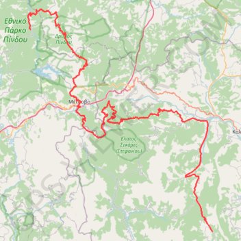
ΕΛΑΤΗ-ΚΑΛΟΜΟΙΡΑ-ΒΑΛΙΑ ΚΑΛΝΤΑ- ΒΟΒΟΥΣΑ
- Distance: 114.8 mi
- Elevation gain: 6,837 m
- Maximum elevation: 1,848 m
- Elevation loss: 6,734 m
- Minimum elevation: 281 m
Interactive trail map
Thank you for supporting this site ❤️
Make a donation
Make a donation
Gear up for your next adventure:
As an Amazon Associate, this site earns from qualifying purchases at no extra cost to you.
Trail profile
- Distance: 114.8 mi
- Elevation gain: 6,837 m
- Maximum elevation: 1,848 m
- Elevation loss: 6,734 m
- Minimum elevation: 281 m
Thank you for supporting this site ❤️
Make a donation
Make a donation
Gear up for your next adventure:
As an Amazon Associate, this site earns from qualifying purchases at no extra cost to you.
About this trail
Name: ΕΛΑΤΗ-ΚΑΛΟΜΟΙΡΑ-ΒΑΛΙΑ ΚΑΛΝΤΑ- ΒΟΒΟΥΣΑ trail, distance, elevation, map, profile, GPS track
Coordinates: 39.50083 21.04705 39.95753 21.53995
Thank you for supporting this site ❤️
Make a donation
Make a donation
Gear up for your next adventure:
As an Amazon Associate, this site earns from qualifying purchases at no extra cost to you.
Other hiking, mountain biking, running and outdoor activity trails
Click on a trail to view its statistics, map and profile.
ELATI-ANTHIRO-MONH SPHLIAS-DRAKOTRYPA-ELATI
Greece > Thessaly and Central Greece > Trikala Regional Unit > Ελάτη > Λιπιότα
Distance: 100.0 mi • Elevation gain: 7,500 m • Maximum elevation: 1,749 m