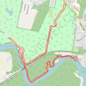
Bongil Bongil National Park
- Distance: 6.9 mi
- Elevation gain: 54 m
- Maximum elevation: 29 m
- Elevation loss: 56 m
- Minimum elevation: 2 m
- Moving time: 54 m 36 s
- Moving speed: 7.6 mph
- Maximum speed: 14.5 mph
- Total time: 54 m 36 s
- Global speed: 7.6 mph
Interactive trail map
Trail profile
- Distance: 6.9 mi
- Elevation gain: 54 m
- Maximum elevation: 29 m
- Elevation loss: 56 m
- Minimum elevation: 2 m
- Moving time: 54 m 36 s
- Moving speed: 7.6 mph
- Maximum speed: 14.5 mph
- Total time: 54 m 36 s
- Global speed: 7.6 mph
About this trail
Name: Bongil Bongil National Park trail, distance, elevation, map, profile, GPS track
Coordinates: -30.37961 153.06306 -30.36258 153.08014
Other hiking, mountain biking, running and outdoor activity trails
Click on a trail to view its statistics, map and profile.
Bongil Picnic Area parkrun
Australia > New South Wales > Coffs Harbour
Distance: 3.1 mi • Elevation gain: 43 m • Maximum elevation: 29 m