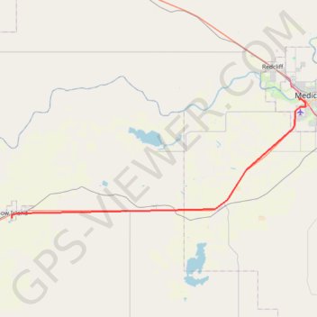
Bow Island - Medicine Hat
- Distance: 36.9 mi
- Elevation gain: 162 m
- Maximum elevation: 834 m
- Elevation loss: 256 m
- Minimum elevation: 702 m
Interactive trail map
Trail profile
- Distance: 36.9 mi
- Elevation gain: 162 m
- Maximum elevation: 834 m
- Elevation loss: 256 m
- Minimum elevation: 702 m
About this trail
Name: Bow Island - Medicine Hat trail, distance, elevation, map, profile, GPS track
Start: Centre Street, Bow Island, Town of Bow Island, Alberta, T0K 0G0, Canada (49.86194 -111.37944)
Coordinates: 49.86194 -111.37944 50.03789 -110.70975
Other hiking, mountain biking, running and outdoor activity trails
Click on a trail to view its statistics, map and profile.
Medicine Hat - Maple Creek
Canada > Alberta > Medicine Hat
#Bike #MedicineHat #MapleCreek
Distance: 56.7 mi • Elevation gain: 280 m • Maximum elevation: 834 m
Lethbridge - Bow Island
Canada > Alberta > Lethbridge County > Lethbridge
Distance: 72.6 mi • Elevation gain: 273 m • Maximum elevation: 924 m