Brisbane Trail Run
Mount Coot-Tha MTB trails
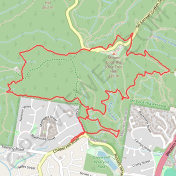
- Distance: 4.9 mi
- Elevation gain: 273 m
- Maximum elevation: 224 m
- Elevation loss: 273 m
- Minimum elevation: 57 m
- Moving time: 1 h 10 m
- Moving speed: 4.1 mph
- Maximum speed: 8.7 mph
- Total time: 1 h 10 m
- Global speed: 4.1 mph
Interactive trail map
Trail profile
- Distance: 4.9 mi
- Elevation gain: 273 m
- Maximum elevation: 224 m
- Elevation loss: 273 m
- Minimum elevation: 57 m
- Moving time: 1 h 10 m
- Moving speed: 4.1 mph
- Maximum speed: 8.7 mph
- Total time: 1 h 10 m
- Global speed: 4.1 mph
About this trail
Name: Brisbane Trail Run trail, distance, elevation, map, profile, GPS track
Coordinates: -27.49389 152.94694 -27.48302 152.96511
Other hiking, mountain biking, running and outdoor activity trails
Click on a trail to view its statistics, map and profile.
Kuta trails
Australia > Queensland > City of Brisbane
Mt Coot-tha Reserve - Brisbane Trail Run
Distance: 3.2 mi • Elevation gain: 214 m • Maximum elevation: 225 m
Mount Coot-Tha trails
Brisbane Trail Run
Distance: 14.5 mi • Elevation gain: 842 m • Maximum elevation: 261 m