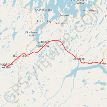
Grand Falls-Windsor - Gander
#Bike #GrandFalls #Windsor #Gander #Newfoundland
- Distance: 61.2 mi
- Elevation gain: 699 m
- Maximum elevation: 145 m
- Elevation loss: 665 m
- Minimum elevation: 10 m
Interactive trail map
Trail profile
- Distance: 61.2 mi
- Elevation gain: 699 m
- Maximum elevation: 145 m
- Elevation loss: 665 m
- Minimum elevation: 10 m
About this trail
Name: Grand Falls-Windsor - Gander trail, distance, elevation, map, profile, GPS track
End: Magee Road, Gander, Newfoundland, Newfoundland and Labrador, A1V 2C8, Canada (48.98546 -54.60849)
Coordinates: 48.93715 -55.67971 49.12254 -54.60587
Other hiking, mountain biking, running and outdoor activity trails
Click on a trail to view its statistics, map and profile.
Gander - Mallorytown
Canada > Newfoundland and Labrador > Gander
#Bike #Gander #Mallorytown #Newfoundland
Distance: 62.9 mi • Elevation gain: 882 m • Maximum elevation: 146 m
Sheppardville - Grand Falls-Windsor
Canada > Newfoundland and Labrador > Sheppardville
#Bike #Sheppardville #GrandFalls #Windsor #Newfoundland
Distance: 63.0 mi • Elevation gain: 566 m • Maximum elevation: 201 m