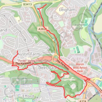
Forder Valley and Efford Marsh
- Distance: 4.5 mi
- Elevation gain: 166 m
- Maximum elevation: 70 m
- Elevation loss: 171 m
- Minimum elevation: 3 m
- Moving time: 1 h 59 m
- Moving speed: 2.3 mph
- Maximum speed: 11.7 mph
- Total time: 2 h 10 m
- Global speed: 2.1 mph
Interactive trail map
Trail profile
- Distance: 4.5 mi
- Elevation gain: 166 m
- Maximum elevation: 70 m
- Elevation loss: 171 m
- Minimum elevation: 3 m
- Moving time: 1 h 59 m
- Moving speed: 2.3 mph
- Maximum speed: 11.7 mph
- Total time: 2 h 10 m
- Global speed: 2.1 mph
About this trail
Name: Forder Valley and Efford Marsh trail, distance, elevation, map, profile, GPS track
Start: Novorossiysk Road, Leigham, Plymouth, England, PL6 8SN, United Kingdom (50.40615 -4.10021)
End: 31, Eggbuckland Road, Austin Farm, Plymouth, England, PL6 5SG, United Kingdom (50.39724 -4.10872)
Coordinates: 50.38829 -4.11034 50.40615 -4.08718
Topography: Plymouth topographic map, elevation, terrain
Other hiking, mountain biking, running and outdoor activity trails
Click on a trail to view its statistics, map and profile.
Saltram, Chelson Meadow, Prince Rock, Tothill
United Kingdom > England > Plymouth > Plympton
Distance: 9.8 mi • Elevation gain: 189 m • Maximum elevation: 33 m
Forder Valley South
United Kingdom > England > Plymouth
Distance: 1.1 mi • Elevation gain: 3 m • Maximum elevation: 89 m