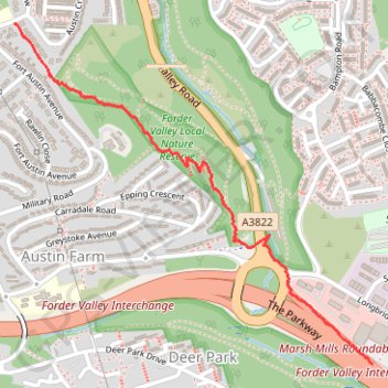
Forder Valley South
- Distance: 1.1 mi
- Elevation gain: 3 m
- Maximum elevation: 89 m
- Elevation loss: 87 m
- Minimum elevation: 4 m
Interactive trail map
Trail profile
- Distance: 1.1 mi
- Elevation gain: 3 m
- Maximum elevation: 89 m
- Elevation loss: 87 m
- Minimum elevation: 4 m
About this trail
Name: Forder Valley South trail, distance, elevation, map, profile, GPS track
End: The Parkway, Leigham, Plympton, Plymouth, England, PL6 8LD, United Kingdom (50.39388 -4.09288)
Coordinates: 50.39388 -4.10739 50.40266 -4.09288
Topography: Plymouth topographic map, elevation, terrain
Other hiking, mountain biking, running and outdoor activity trails
Click on a trail to view its statistics, map and profile.
Forder Valley and Efford Marsh
United Kingdom > England > Plymouth
Distance: 4.5 mi • Elevation gain: 166 m • Maximum elevation: 70 m