Make a donation
Gear up for your next adventure:
As an Amazon Associate, this site earns from qualifying purchases at no extra cost to you.
Walk through the park and along marshes
- Distance: 1.3 mi
- Elevation gain: 4 m
- Maximum elevation: 2 m
- Elevation loss: 4 m
- Minimum elevation: 0 m
Interactive trail map
Make a donation
Gear up for your next adventure:
As an Amazon Associate, this site earns from qualifying purchases at no extra cost to you.
Trail profile
- Distance: 1.3 mi
- Elevation gain: 4 m
- Maximum elevation: 2 m
- Elevation loss: 4 m
- Minimum elevation: 0 m
Make a donation
Gear up for your next adventure:
As an Amazon Associate, this site earns from qualifying purchases at no extra cost to you.
About this trail
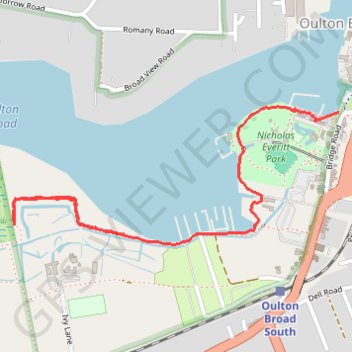
Name: Walk through the park and along marshes trail, distance, elevation, map, profile, GPS track
Coordinates: 52.47080 1.69592 52.47446 1.71004
Topography: East Suffolk topographic map, elevation, terrain
Make a donation
Gear up for your next adventure:
As an Amazon Associate, this site earns from qualifying purchases at no extra cost to you.
Other hiking, mountain biking, running and outdoor activity trails
Click on a trail to view its statistics, map and profile.
Gull Wing Lowestoft loop
United Kingdom > England > Suffolk > East Suffolk > Lowestoft > Oulton Broad
Distance: 5.3 mi • Elevation gain: 37 m • Maximum elevation: 11 m