Gull Wing Lowestoft loop
- Distance: 5.3 mi
- Elevation gain: 37 m
- Maximum elevation: 11 m
- Elevation loss: 38 m
- Minimum elevation: 0 m
- Moving time: 2 h 6 m
- Moving speed: 2.5 mph
- Maximum speed: 3.1 mph
- Total time: 2 h 21 m
- Global speed: 2.2 mph
Interactive trail map
Trail profile
- Distance: 5.3 mi
- Elevation gain: 37 m
- Maximum elevation: 11 m
- Elevation loss: 38 m
- Minimum elevation: 0 m
- Moving time: 2 h 6 m
- Moving speed: 2.5 mph
- Maximum speed: 3.1 mph
- Total time: 2 h 21 m
- Global speed: 2.2 mph
About this trail
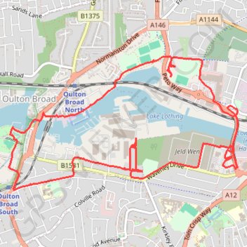
Name: Gull Wing Lowestoft loop trail, distance, elevation, map, profile, GPS track
Coordinates: 52.46932 1.70760 52.48000 1.73754
Topography: East Suffolk topographic map, elevation, terrain
Other hiking, mountain biking, running and outdoor activity trails
Click on a trail to view its statistics, map and profile.
Walk through the park and along marshes
United Kingdom > England > Suffolk > East Suffolk > Oulton Broad
Distance: 1.3 mi • Elevation gain: 4 m • Maximum elevation: 2 m