Trailrun Stratford-upon-Avon
Morning Run
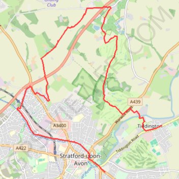
- Distance: 8.7 mi
- Elevation gain: 140 m
- Maximum elevation: 112 m
- Elevation loss: 142 m
- Minimum elevation: 36 m
- Moving time: 1 h 22 m
- Moving speed: 6.3 mph
- Maximum speed: 10.3 mph
- Total time: 1 h 23 m
- Global speed: 6.2 mph
Interactive trail map
Trail profile
- Distance: 8.7 mi
- Elevation gain: 140 m
- Maximum elevation: 112 m
- Elevation loss: 142 m
- Minimum elevation: 36 m
- Moving time: 1 h 22 m
- Moving speed: 6.3 mph
- Maximum speed: 10.3 mph
- Total time: 1 h 23 m
- Global speed: 6.2 mph
About this trail
Name: Trailrun Stratford-upon-Avon trail, distance, elevation, map, profile, GPS track
Coordinates: 52.18972 -1.73099 52.22893 -1.67492
Topography: Stratford-on-Avon topographic map, elevation, terrain
Other hiking, mountain biking, running and outdoor activity trails
Click on a trail to view its statistics, map and profile.
Trailrun to Snitterfield
United Kingdom > England > Warwickshire > Stratford-on-Avon > Stratford-upon-Avon > Lower Clopton
Distance: 6.1 mi • Elevation gain: 91 m • Maximum elevation: 114 m
River Avon Loop Walk
United Kingdom > England > Warwickshire > Stratford-on-Avon > Stratford-upon-Avon
Distance: 3.2 mi • Elevation gain: 17 m • Maximum elevation: 43 m