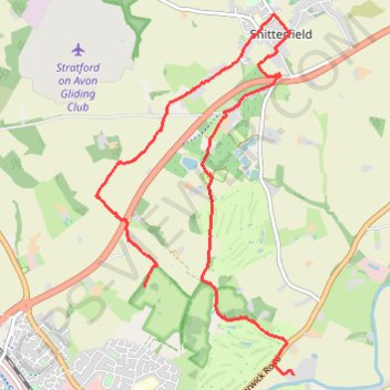
Trailrun to Snitterfield
- Distance: 6.1 mi
- Elevation gain: 91 m
- Maximum elevation: 114 m
- Elevation loss: 142 m
- Minimum elevation: 36 m
- Moving time: 1 h 7 s
- Moving speed: 6.1 mph
- Maximum speed: 8.2 mph
- Total time: 1 h 1 m
- Global speed: 6.0 mph
Interactive trail map
Trail profile
- Distance: 6.1 mi
- Elevation gain: 91 m
- Maximum elevation: 114 m
- Elevation loss: 142 m
- Minimum elevation: 36 m
- Moving time: 1 h 7 s
- Moving speed: 6.1 mph
- Maximum speed: 8.2 mph
- Total time: 1 h 1 m
- Global speed: 6.0 mph
About this trail
Name: Trailrun to Snitterfield trail, distance, elevation, map, profile, GPS track
Coordinates: 52.20374 -1.71486 52.23815 -1.68409
Topography: Stratford-on-Avon topographic map, elevation, terrain
Other hiking, mountain biking, running and outdoor activity trails
Click on a trail to view its statistics, map and profile.
Trailrun Stratford-upon-Avon
United Kingdom > England > Warwickshire > Stratford-on-Avon > Stratford-upon-Avon > Tiddington
Morning Run
Distance: 8.7 mi • Elevation gain: 140 m • Maximum elevation: 112 m