Make a donation
Gear up for your next adventure:
As an Amazon Associate, this site earns from qualifying purchases at no extra cost to you.
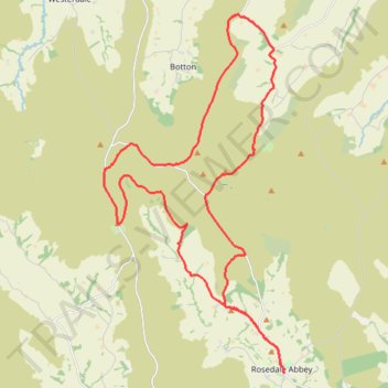
Rosedale Abbey north loop to Fryup Dale
- Distance: 19.8 mi
- Elevation gain: 701 m
- Maximum elevation: 422 m
- Elevation loss: 701 m
- Minimum elevation: 135 m
- Moving time: 2 h 31 m
- Moving speed: 7.8 mph
- Maximum speed: 33.1 mph
- Total time: 3 h 12 m
- Global speed: 6.2 mph
Interactive trail map
Make a donation
Gear up for your next adventure:
As an Amazon Associate, this site earns from qualifying purchases at no extra cost to you.
Trail profile
- Distance: 19.8 mi
- Elevation gain: 701 m
- Maximum elevation: 422 m
- Elevation loss: 701 m
- Minimum elevation: 135 m
- Moving time: 2 h 31 m
- Moving speed: 7.8 mph
- Maximum speed: 33.1 mph
- Total time: 3 h 12 m
- Global speed: 6.2 mph
Make a donation
Gear up for your next adventure:
As an Amazon Associate, this site earns from qualifying purchases at no extra cost to you.
About this trail
Name: Rosedale Abbey north loop to Fryup Dale trail, distance, elevation, map, profile, GPS track
Coordinates: 54.35280 -0.96165 54.44007 -0.88628
Topography: North Yorkshire topographic map, elevation, terrain
Make a donation
Gear up for your next adventure:
As an Amazon Associate, this site earns from qualifying purchases at no extra cost to you.
Other hiking, mountain biking, running and outdoor activity trails
Click on a trail to view its statistics, map and profile.
Hartoft End Loop
United Kingdom > England > North Yorkshire > Rosedale Abbey
Distance: 12.9 mi • Elevation gain: 499 m • Maximum elevation: 372 m
Church Houses Loop Mountain Biking
United Kingdom > England > North Yorkshire > Church Houses
Distance: 14.3 mi • Elevation gain: 645 m • Maximum elevation: 393 m
Lastingham MTB Loop
United Kingdom > England > North Yorkshire > Lastingham
Distance: 27.5 mi • Elevation gain: 1,046 m • Maximum elevation: 370 m
Westerdale top
United Kingdom > England > North Yorkshire > Westerdale
Mountain Biking
Distance: 17.0 mi • Elevation gain: 663 m • Maximum elevation: 422 m
Make a donation
Gear up for your next adventure:
As an Amazon Associate, this site earns from qualifying purchases at no extra cost to you.
Hartoft Rigg
United Kingdom > England > North Yorkshire > Rosedale Abbey
Distance: 5.8 mi • Elevation gain: 255 m • Maximum elevation: 287 m
Farndale
United Kingdom > England > North Yorkshire > Appleton-le-Moors
Ryedale Mountain Biking
Distance: 32.9 mi • Elevation gain: 1,251 m • Maximum elevation: 407 m