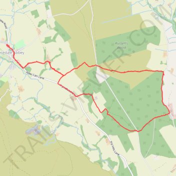
Hartoft Rigg
- Distance: 5.8 mi
- Elevation gain: 255 m
- Maximum elevation: 287 m
- Elevation loss: 254 m
- Minimum elevation: 134 m
- Moving time: 3 h 3 m
- Moving speed: 1.9 mph
- Maximum speed: 6.7 mph
- Total time: 4 h 22 m
- Global speed: 1.3 mph
Interactive trail map
Trail profile
- Distance: 5.8 mi
- Elevation gain: 255 m
- Maximum elevation: 287 m
- Elevation loss: 254 m
- Minimum elevation: 134 m
- Moving time: 3 h 3 m
- Moving speed: 1.9 mph
- Maximum speed: 6.7 mph
- Total time: 4 h 22 m
- Global speed: 1.3 mph
About this trail
Name: Hartoft Rigg trail, distance, elevation, map, profile, GPS track
Coordinates: 54.34039 -0.88858 54.35536 -0.84066
Topography: North Yorkshire topographic map, elevation, terrain
Other hiking, mountain biking, running and outdoor activity trails
Click on a trail to view its statistics, map and profile.
Hartoft End Loop
United Kingdom > England > North Yorkshire > Rosedale Abbey
Distance: 12.9 mi • Elevation gain: 499 m • Maximum elevation: 372 m
Rosedale Abbey north loop to Fryup Dale
United Kingdom > England > North Yorkshire > Rosedale Abbey
Distance: 19.8 mi • Elevation gain: 701 m • Maximum elevation: 422 m
Hartoft End Loop
United Kingdom > England > North Yorkshire
Ryedale Mountain Biking
Distance: 12.1 mi • Elevation gain: 421 m • Maximum elevation: 330 m
Lastingham MTB Loop
United Kingdom > England > North Yorkshire > Lastingham
Distance: 27.5 mi • Elevation gain: 1,046 m • Maximum elevation: 370 m
Farndale
United Kingdom > England > North Yorkshire > Appleton-le-Moors
Ryedale Mountain Biking
Distance: 32.9 mi • Elevation gain: 1,251 m • Maximum elevation: 407 m