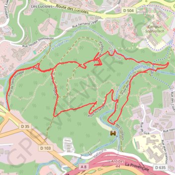
Mougins - Parc de la Valmasque
- Distance: 3.6 mi
- Elevation gain: 131 m
- Maximum elevation: 138 m
- Elevation loss: 127 m
- Minimum elevation: 69 m
Interactive trail map
Trail profile
- Distance: 3.6 mi
- Elevation gain: 131 m
- Maximum elevation: 138 m
- Elevation loss: 127 m
- Minimum elevation: 69 m
About this trail
Name: Mougins - Parc de la Valmasque trail, distance, elevation, map, profile, GPS track
Coordinates: 43.60735 7.05490 43.61339 7.07314
Other hiking, mountain biking, running and outdoor activity trails
Click on a trail to view its statistics, map and profile.
Marathon des Alpes-Maritimes Nice - Cannes
France > Provence-Alpes-Côte d'Azur > Maritime Alps > Nice
Distance: 26.5 mi • Elevation gain: 246 m • Maximum elevation: 34 m
1 LUCENA - MONTPELLIER
Distance: 1,842.0 mi • Elevation gain: 29,500 m • Maximum elevation: 1,048 m
PT23DS2 Lörrach → Cadaqués
Germany > Baden-Württemberg > Landkreis Lörrach > Lörrach (Kernstadt)
Distance: 652.9 mi • Elevation gain: 13,130 m • Maximum elevation: 1,505 m