Import a GPX file

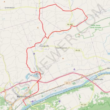
Bike from Bloomsburg

#Bike #Loop #Road #Countryside #River #Nature

  • Distance: 34.0 mi
  • Elevation gain: 830 m
  • Maximum elevation: 354 m
  • Elevation loss: 814 m
  • Minimum elevation: 143 m

Interactive trail map

Trail profile

  • Distance: 34.0 mi
  • Elevation gain: 830 m
  • Maximum elevation: 354 m
  • Elevation loss: 814 m
  • Minimum elevation: 143 m

About this trail

Other hiking, mountain biking, running and outdoor activity trails

Click on a trail to view its statistics, map and profile.

Bloomsburg

United States > Pennsylvania > Columbia County > Bloomsburg

#Bike #Loop

Distance: 36.8 mi • Elevation gain: 989 m • Maximum elevation: 360 m

Gear up for your next adventure:

🧢Waterproof Hiking Hats - Keep the rain off your face while studying topographic maps
🪢Paracord - Multi-purpose cord for camping and survival
🧥Packable Down Jackets - Lightweight warmth that compresses small in your bag
👖Packable Overtrousers - Quick-deploy rain protection for legs in sudden storms
🗺️Ordnance Survey Maps - Essential paper maps for hiking across the UK national parks

As an Amazon Associate, this site earns from qualifying purchases at no extra cost to you.