Import a GPX file

Bloomsburg

#Bike #Loop

  • Distance: 36.8 mi
  • Elevation gain: 989 m
  • Maximum elevation: 360 m
  • Elevation loss: 953 m
  • Minimum elevation: 146 m

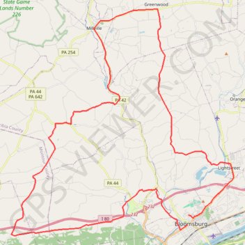
Interactive trail map

Trail profile

  • Distance: 36.8 mi
  • Elevation gain: 989 m
  • Maximum elevation: 360 m
  • Elevation loss: 953 m
  • Minimum elevation: 146 m

About this trail

Other hiking, mountain biking, running and outdoor activity trails

Click on a trail to view its statistics, map and profile.

Bike from Bloomsburg

United States > Pennsylvania > Columbia County > Bloomsburg

#Bike #Loop #Road #Countryside #River #Nature

Distance: 34.0 mi • Elevation gain: 830 m • Maximum elevation: 354 m

Gear up for your next adventure:

🧥Softshell Jackets - Breathable jackets for active outdoor use
🧭Orienteering Compasses - Accurate compasses for map-based navigation
📻Hand-Crank Emergency Radios - Stay updated on weather warnings in remote areas
Insulated Travel Mugs - Keep drinks hot while surveying the landscape from a summit
🪓Outdoor Multitools - Versatile tools for hiking and camping

As an Amazon Associate, this site earns from qualifying purchases at no extra cost to you.