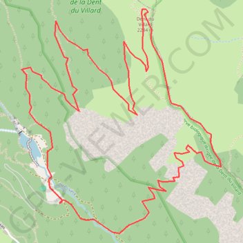
Dent du Villard : Depuis le lac de la Rosière
- Distance: 5.3 mi
- Elevation gain: 823 m
- Maximum elevation: 2,278 m
- Elevation loss: 823 m
- Minimum elevation: 1,537 m
Interactive trail map
Trail profile
- Distance: 5.3 mi
- Elevation gain: 823 m
- Maximum elevation: 2,278 m
- Elevation loss: 823 m
- Minimum elevation: 1,537 m
About this trail
Name: Dent du Villard : Depuis le lac de la Rosière trail, distance, elevation, map, profile, GPS track
Coordinates: 45.40562 6.66473 45.42013 6.68308
Other hiking, mountain biking, running and outdoor activity trails
Click on a trail to view its statistics, map and profile.
PT23DS2 Lörrach → Cadaqués
Germany > Baden-Württemberg > Landkreis Lörrach > Lörrach (Kernstadt)
Distance: 652.9 mi • Elevation gain: 13,130 m • Maximum elevation: 1,505 m