Montmin-Balmettes-Solliet
- Distance: 18.4 mi
- Elevation gain: 1,730 m
- Maximum elevation: 1,168 m
- Elevation loss: 1,731 m
- Minimum elevation: 482 m
Interactive trail map
Trail profile
- Distance: 18.4 mi
- Elevation gain: 1,730 m
- Maximum elevation: 1,168 m
- Elevation loss: 1,731 m
- Minimum elevation: 482 m
About this trail
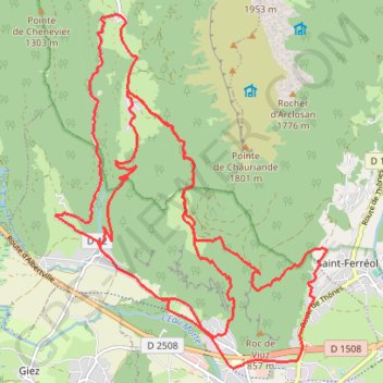
Name: Montmin-Balmettes-Solliet trail, distance, elevation, map, profile, GPS track
Coordinates: 45.75303 6.25208 45.79809 6.30160
Other hiking, mountain biking, running and outdoor activity trails
Click on a trail to view its statistics, map and profile.
Dag 3: Forclaz - Aravis
France > Auvergne-Rhône-Alpes > Upper Savoy > Le Grand-Bornand > Le Mont
Distance: 64.0 mi • Elevation gain: 2,932 m • Maximum elevation: 1,488 m
PT23DS2 Lörrach → Cadaqués
Germany > Baden-Württemberg > Landkreis Lörrach > Lörrach (Kernstadt)
Distance: 652.9 mi • Elevation gain: 13,130 m • Maximum elevation: 1,505 m
Montmin-Balmettes-Solliet
France > Auvergne-Rhône-Alpes > Upper Savoy > Faverges-Seythenex > Mercier
Distance: 17.5 mi • Elevation gain: 1,724 m • Maximum elevation: 1,168 m