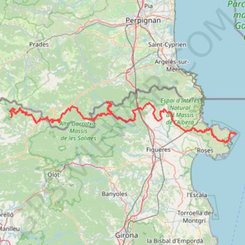
1 Day ACT Py
- Distance: 128.0 mi
- Elevation gain: 6,902 m
- Maximum elevation: 1,910 m
- Elevation loss: 5,708 m
- Minimum elevation: 1 m
Interactive trail map
Trail profile
- Distance: 128.0 mi
- Elevation gain: 6,902 m
- Maximum elevation: 1,910 m
- Elevation loss: 5,708 m
- Minimum elevation: 1 m
About this trail
Name: 1 Day ACT Py trail, distance, elevation, map, profile, GPS track
Coordinates: 42.28893 2.28981 42.42388 3.31620
Other hiking, mountain biking, running and outdoor activity trails
Click on a trail to view its statistics, map and profile.
Camino Natural de la Muga
Spain > Catalonia > Upper Empordà > Empuriabrava > Castelló d'Empúries
Camino Natural de la Muga
Distance: 24.5 mi • Elevation gain: 543 m • Maximum elevation: 229 m
GR 10 - Traversée des Pyrénées
France > Occitania > Pyrénées-Orientales > Banyuls-sur-Mer
Distance: 543.6 mi • Elevation gain: 57,000 m • Maximum elevation: 2,599 m
1 LUCENA - MONTPELLIER
Distance: 1,842.0 mi • Elevation gain: 29,500 m • Maximum elevation: 1,048 m
PT23DS2 Lörrach → Cadaqués
Germany > Baden-Württemberg > Landkreis Lörrach > Lörrach (Kernstadt)
Distance: 652.9 mi • Elevation gain: 13,130 m • Maximum elevation: 1,505 m
Southern section — European Divide Trail
France > Auvergne-Rhône-Alpes > Drôme > Valence
Distance: 1,506.1 mi • Elevation gain: 42,375 m • Maximum elevation: 2,005 m